| Death Valley Hiking, February 2009 |
|---|
| | | Home Page | | |
|---|
A Day and a Night in Las Vegas
Our hiking group was to meet at the Las Vegas airport late Sunday afternoon. No flight from the East Coast would get us there early enough. Taking a Saturday morning flight from Ithaca, NY, to Las Vegas via Newark we arrived in the early afternoon, plenty of time for my first visit to Las Vegas Boulevard, The Strip. Rivers of people flowed through streets, in, through and out of casinos. I quickly learned the only way to prevent shills from pushing come-ons for hookers into my hands was to keep my hands in my pockets!

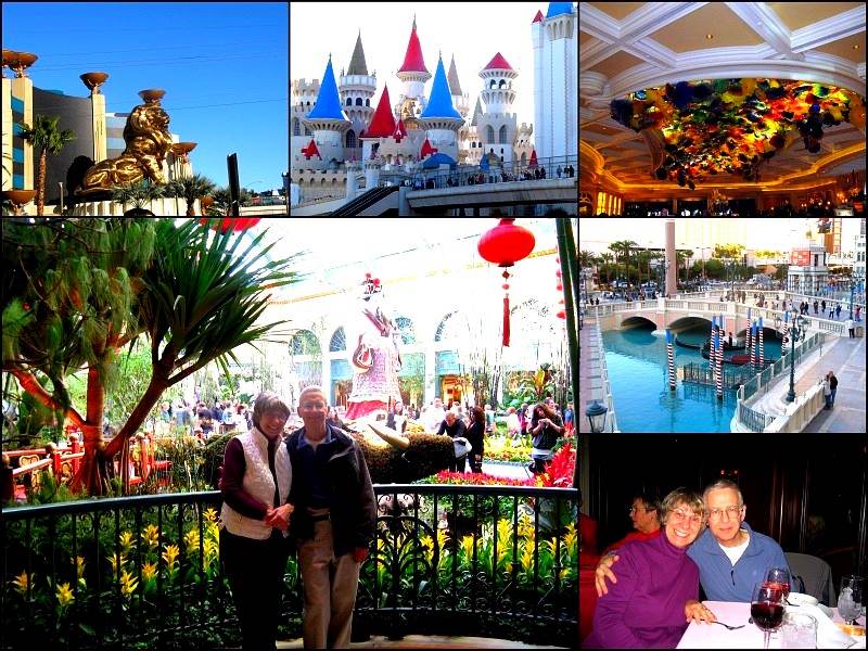
Clockwise from upper left: MGM Grand Hotel & Casino - The DoubleTree shuttle dropped us below the MGM's distinctive bronze lion. The Excaliber is directly across from the MGM, a Disney theme park run amok between the skyline of New York, New York and the pyramids of the Luxor. The main lobby ceiling of the Bellagio Hotel & Casino features a Dale Chihuly 2000 flower hand-blown glass sculpture, Fiori di Como , The Flowers of Como (Italy). Off the hotel's public square The Venetian offers gondola rides. As we ate dinner there at Zeffirino Ristorante ( now closed ) Across from the restaurant a human statue with skin and garments the color of marble performed. After putting a dollar in his basket Joyce received a "kiss kiss" in appreciation.
Returning to the Grand for our last stop of the night we wandered through a maze of restaurants, gaming tables, slot machines and boutiques. leaving the Grand was harder than entering as we wandered aimlessly. A fortuitously sited Häagen-Dazs shop saved us from starvation and total exhaustion.
A Day and a Night in Las Vegas
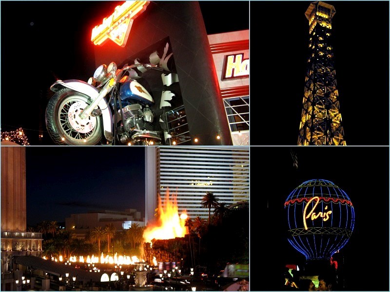
Darkness, and a humongous amount of electrical power, transforms The Strip. Clockwise from upper left above: Pardon the pun but the Harley Davidson Café jumps out at you. The Paris Las Vegas Hotel & Casino is as close to the real Paris as I'll get in the near future. The balloon's nothing special to look at during the day but has to be one of the prettiest sights when lit at night. The appearance of the Mirage's Volcano also improves in the dark as fire and lava play on cue.
In the photo above, top, The Eddie World gas station houses the Death Valley Nut & Candy Co.. More importantly the ice cream stores abides within. Served no desert with evening dinner we joined the troupe taking the short hike across the parking lot then returning to our rooms with generous scoops of fresh made ice cream.
Above, Beatty Museum and Historical Society is a gem, It's exhibit spaces cover every inch of floor chock full of artifacts. Among the old saddles, mining tools and vintage photographs was a collection of electronic equipment. Among them were a Hallicrafters S38B receiver and a Conar vacuum tube tester. I was given my first amateur radio receiver, the S38B, in the late 1950's. Earning my first ham radio license in 1960, KN8UWZ, I used it along with a Heath AT-1 transmitter to make my first contacts. The hobby started me on the road to become an electrical engineer and a rewarding career. If you are old enough you may remember almost every drug store had a tube tester. Your TV failing, as they often did in the days before transistors and integrated circuits, just pull the tubes, cart them to the local drug store and plug'm in. The electronic section of the museum was pure nostalgia for me.
| | | Home Page | | |
|---|
Furnace Creek Visitor Center and Harmony Borax Works
With 27 hikers in our group it took three vans to transfer us to the Stagecoach Hotel & Casino in Beatty, NV, our home base for the week. Hotel & Casino stretches things a bit after what we saw in Las Vegas but it was clean and the food was good.
When Sunday night's welcome reception was history we turned in eager to get to the Valley the following morning. We drove west from Beatty on route 374 toward the eastern entrance of Death Valley National Park. Descending through Daylight Pass in the Amargosa Mountains we entered Death Valley at Hell's Gate.
Furnace Creek Visitor Center and Harmony Borax Works
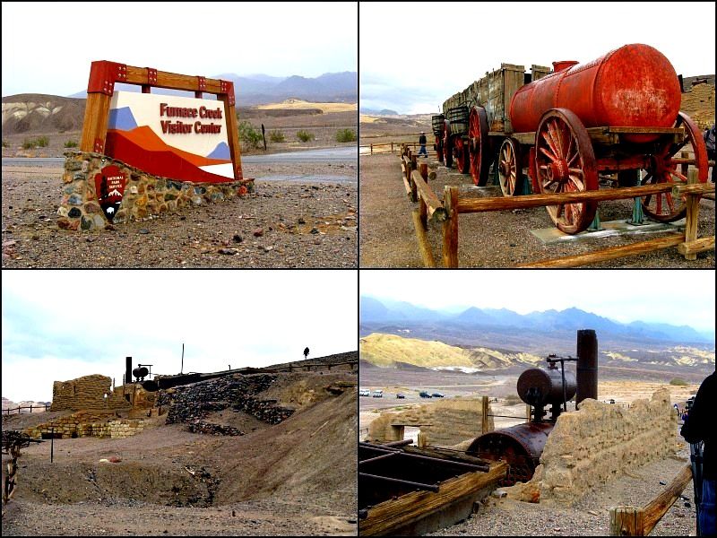
Definitely don't eat inside the visitor center or a friendly park ranger will ask you to take it outside! A short walk from the center is the site of the Harmony Borax Works. Neither gold nor silver contributed to the mineral wealth extracted from the Valley. Borax however, even in the 1880's, was in great demand. From 1883 to 1888 20-mule teams, 18 mules and two horses to be exact but let's not quibble, hauled 20 million tons of refined Borax, 30 tons at a time, from the works 165 miles to the railhead at Mojave, NV. Discovery of Borax deposits close to the rail line spelled the end of the Harmony works.
Clockwise from the upper right: 500 gallons of water for the 2-man team and critters were hauled in a wagon behind each load. Steam from the boiler heated water for the processing tanks. The works and wagon are originals. Before dinner some of us watched three episodes of Death Valley Days featuring the original host, the "The Old Ranger". The 50's commercials confirmed that father knows best, mom always wears a tea skirt and heels around the house and kids listen to their parents.
Badwater - The Lowest, Driest, And Hottest Location In North America
Badwater - The Lowest, Driest, And Hottest Location In North America
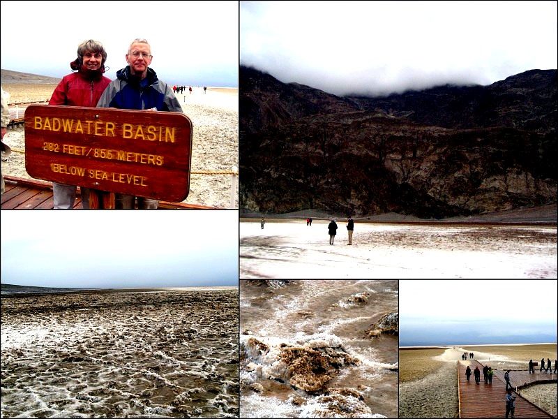
At 282 feet below sea level the Badwater basin could be the navel of North America. Dry it was not. Over several days enough rain fell in the valley for Badwater Basin to actually contain Bad Water. Hot is was not. We bundled against a cold that would later bring snow to Daylight Pass. A boardwalk, lower right above, leads to the salt flats but first one's compelled to have a picture taken in front of the Below Sea Level sign. Actually it's not at the lowest point in North America. Traveling to the lowest point though provides the visitor an opportunity to fall through the thin salt crust, lower left, above. A close-up of a section of the flats, bottom center above, details the rise of salt crystals due to alternate freezing and thawing of the liquid below the surface. Yes, I tasted it. Not pure sodium chloride, table salt, but close enough. Looking back toward the mountains … the sea level marker is 2/3 of the way up on the right.
| | | Home Page | | |
|---|
Let It Snow, Let It Snow, Let It Snow
Let It Snow, Let It Snow, Let It Snow
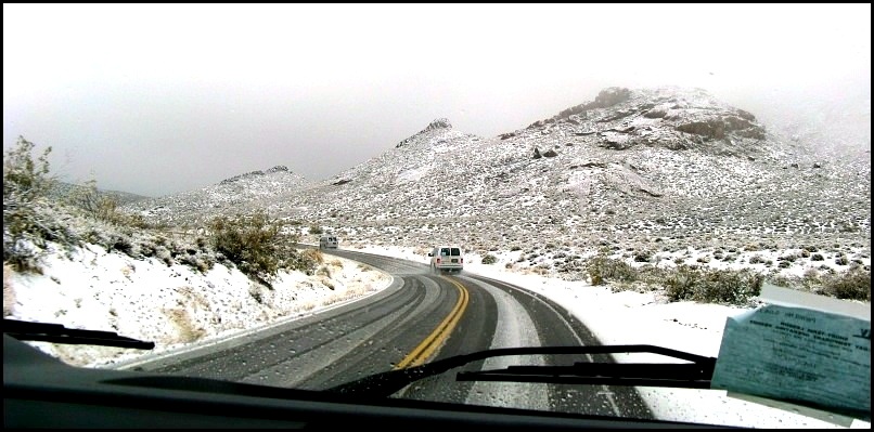
Though we came to Death Valley for relief from NY snow and cold who'd have thought it would follow us! At the end of the first day we returned to Beatty through Daylight Pass. As we gained altitude the rain, rare enough in the valley, turned to slush then to snow. Our guides were tickled that we had an opportunity to see this extraordinary event! Lucky us.
Tuesday brought fair weather and our first real hiking opportunity, Mosaic Canyon in the Tucki mountain. Upper left above is the alluvial fan, lying at the canyon entrance. A short way into the canyon the path suddenly narrows, above lower left. Thousands of years of flash floods have polished the hard Noonday Dolomite, a chemically altered form of limestone, walls so that they can pass for marble. In another of our Rock Goddess photo series Joyce clambers over rocks poking up through the streambed. Ed takes a ride down a dry falls. Some of us took a small ravine off the main trail for a bit of rock scrambling. Our rock group paused before Second Falls for lunch and photo, upper right. Yours truly is front and center in the dark blue pullover.
| | | Home Page | | |
|---|
Sand. This was my mental image of Death Valley prior to arriving! I could imaging Humphrey Bogart in "Sahara" fighting WWII Germans or watching helplessly in "The Treasure of Sierra Madre"as his ill gotten gold dust blows away in the desert wind. Alas no Germans, no gold. We split into two groups according to interest, hunting critters or climbing the tallest dunes. Near the road, above, upper left and lower right, the terrain flattened sporting the occasional scrubby bush, great places for critters to hide. Toward the center of the dune field we struck all sand. With sand constantly shifting underfoot hiking poles were essential for me to get up and down the dunes. Ant-like, we climb the ridge of the highest dune for this nifty group shot. Look for me in the red short sleeve shirt, back row, second on the right.
In 1904 insurance executive Albert Johnson of Chicago invested in a Scotty gold mine scam. Walter Scott, a.k.a. Death Valley Scotty, was a former rodeo star and full time flimflam artist. Meeting in 1904 they made an unlikely pair. Johnson, formerly a civil engineer and mining entrepreneur soon found there was no gold, no mine … and that he didn't much care. Johnson grew to love the desert, Scotty's friendship worth more than gold to him. Bankrolled by Johnson Scotty spent freely continuing to tout the gold mine as his source of wealth.
Johnson returned to the desert and Scotty repeatedly, living rough. Eventually Johnson's wife, Bessie, wanted a more comfortable home away from desert critters. Though unfinished the home, upper right, is beautiful. I particularly enjoyed the wonderful tile work, bottom center and upper left.
Scotty outlived Johnson who died in the late 40's. Scotty continued to live in comfort, for him, in an out-of-the-way shack tucked in the hills that Johnson had built for him. Scotty died in the early 50's and is buried on a hill overlooking the castle alongside his favorite dog, Windy.
Special thanks to our tour leader for the unusual group portrait, lower left.
| | | Home Page | | |
|---|
To go down or to go around that is the question. Whether it is better to suffer the slings and arrows of the rim trail with its' precipitous prospects or, by scrambling down and up slippery volcanic ash, court heavy breathing and leaden legs. Joyce took the 1.5 mile rim route, above upper right and lower center, while I the 780 foot down and up, above lower left.
When would I ever get a second opportunity to descend a volcano? Going down the crater was simple, lean back and skid on your heels, straight down. Recent rains created a lake at the bottom. While cold and windy at the top layers were shed on the way to the floor, upper left. The trail up and out offered numerous opportunities to stop and enjoy the view … and catch my breath, above lower right.
We began our longest hike in Golden Canyon. Gathering in the canyon mouth we check our gear before entering, above top left. Where canyon walls are close together floodwater speeds up polishing the walls smooth by the mixture of small particles, cobbles and boulders carried along in the water, above upper right. Where the canyon walls widen floodwaters slow down and, unable to carry the heavier material deposits them on the canyon floor, above lower right. Why do they call it Golden Canyon? See above lower left.
Above, lower left, we left the Golden Canyon trail striking for Zabriskie Point. We're in "The Badlands" preparing to climb toward Manly Beacon, bottom center. Is that a mountain goat track? No, that's the trail beneath Manly Beacon, above bottom right. A bit of vertigo set in and I was acutely aware of the consequences of a misstep. Walk, or stop to take pictures. Both simultaneously are not recommended. Joyce walked out on a premonitory below Manly Beacon. I passed, already on a narrow enough spot. Yeah Joyce!
| | | Home Page | | |
|---|
After lunch at Zabriskie Point we divided into two groups. Joyce saw Artists Palette on Artist's Drive. Minerals, iron, mica, and manganese among them, are responsible for the beautiful pastels, above upper left.
Our group followed the trail through Gower Gulch. Gower Gulch captured Furnace Creek in 1941 … with the help of a bulldozer. The owners of the The Inn at Furnace Creek feared rains would flood them out. Requirements for environmental impact statements were far into the future in the 40's. The volume of water diverted into Gower Gulch in one go achieved what nature might have taken centuries to accomplish. We're just entering the gulch, above right center. Next, upper right, we're walking along the rubble-covered bed of the Gulch. The picture doesn't do justice to the scale of the place, above, lower left, were shown scrambling down one of several dry falls we encountered. The contrast between the pale hills and vivid red deposits caught my eye.
So ended our last hike of the trip.
Founded in 1904 Rhyolite was on its' way to becoming "The Chicago of the West" when gold was discovered. Population quickly exceeded 10,000 in the immediate area. Schools, banks, stores, a jail, then an even larger school were built. Telephone lines and electric streetlights were installed along roadways. It became a railroad hub handling trains from north and south serving other gold mining towns. It was a thoroughly modern thriving city with its' future ahead of it. Then the gold ran out. Between the San Francisco fire of 1906 and the Bank Panic of 1907 investment funds dried up. Within a year the populations shrunk to 400 or so. The end had come for "The Chicago of the West."
Rhyolite's become a popular ghost town. Movies were shot in the town from 1925 into this century. Ruins of The Cook Bank Building are visible above, upper left. Tarpaper shacks, above upper right, were lived in into the 70's. The Bottle House pictured above lower right, was built in 1906 of approximately 30,000, mostly beer, bottles and is one of a few still standing in the U.S. The Porter Brothers' Rhyolite Mercantile, above lower left, has a few miles, literally, on it. As Rhyolite faltered the building was bought then moved, lock stock and barrel, to another town. When that town failed there was still enough business in Rhyolite to move it back!
| | | Home Page | | |
|---|
One of kind? Belgian artist Albert Szukalski founded the Rhyolite, NV, museum in the mid-80's. He contributed its' first work "The Last Supper" an alternative universe representation of Leonardo Da Vinci's Last Supper. Above, upper left, is a portion of the plaster and fiberglass sculpture. Continuing clockwise above Joyce and I pose for our portrait on Sofie Siegmann's Sit Here. Another Szukalski sculpture, The Ghost Rider (1984), preparing to mount its' bicycle. The model was draped in a plaster impregnated fabric which, when dried, was coated with fiberglass. Next shown is Fred Bervoets's Tribute to Shorty Harris. The penguin is said to represent the sculpture who felt as out of place in the desert as would the Antarctic bird. Lastly, Lady Desert: The Venus of Nevada (1992), a.k.a. The Pink Lady by Dr. Hugo Heyrman . The larger than life, 25 feet tall, Lego© like painted lady's built of cinder blocks. She appears to be a true blonde.
| | | Home Page | | |
|---|