Kirkwall

| Scotland, Orkney Islands Mainland, August, 2014 |
|---|
| | | Return to Home Page | | |
|---|
Introduction
Our Scottish vacation in hand, Joyce researched and booked a privately guided tour of the Orkney Islands Mainland with Kinlay at Orkney Uncovered. After a brief stay in Inverness acclimatizing after the long flight from Ithaca we flew from there to the Kirkwall airport where we were met by Kinlay, our guide. On arrival at the airport cleared a bucket list item, being greeted by a hand held sign with my name on it!
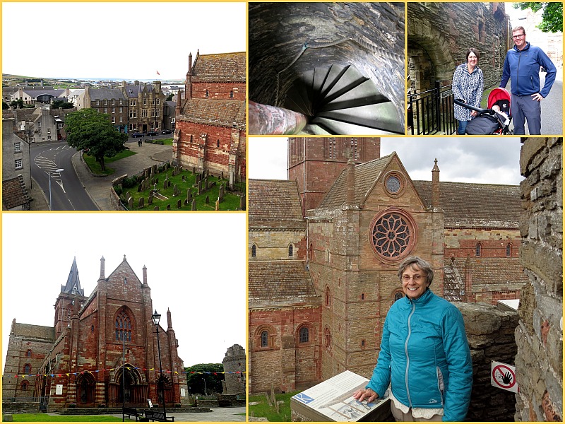
In the photo above, upper left, a view of center city, Kirkwall, from the upper story of the Earl's Palace. Compact, the entire town was within walking distance of our B&B. Top center, no fan of small, tight spaces and with a new left knee, my exploration of the Earl's castle halted at the base of the spiral staircase leading to the upper stories. Photo courtesy of Joyce. The Earl, Robert, and his son Patrick, 'Black Patie', in particular rode roughshod over their subjects. Above right, family portrait with Kinlay, Kirstin, and Benjamin, his wee boy. Bottom right, From the top story of the Earls Palace Joyce had a bird's eye view of Saint Magnus Catheral also seen lower left. Inside the cathedral Kinlay showed us the faint makers marks carved on the stone columns, the craftsman's way of saying "I Made This". The cathedral has a sinister past, Marwick's Hole - the Cathedral dungeon. Built in the mid 1500's, was the final destination of men, women and children accused of witchcraft.
| | | Return to Home Page | | |
|---|
As a 'ham' radio operator, aircraft and WWII buff I made beeline for the museum. Two knowledgeable, helpful volunteers answered my questions. In the photo above, left, the T1154/R1155 transmitter(upper) receiver (lower) pairs were installed in both the Lancaster heavy bomber and Sunderland flying boats. Upper right, a R1116a aircraft receiver. Paired with its' companion transmitter, the R1155, they went to war in the Fairey Swordfish. Lower right the ubiquitous Type 19 Wireless Transceiver.
| | | Return to Home Page | | |
|---|
Historic Orkney - The Mesolithic Through the Norse Invasions

Historic Orkney - The Mesolithic Through the Norse Invasions
The first settlers were hunter-gatherers in the Mesolithic age, prehistory - 7000 TO 4000 BCE, extending through the Norse Invasions in the 700's. In France I touched a Roman wall, 1600 years old. I thought I knew "old", naive.
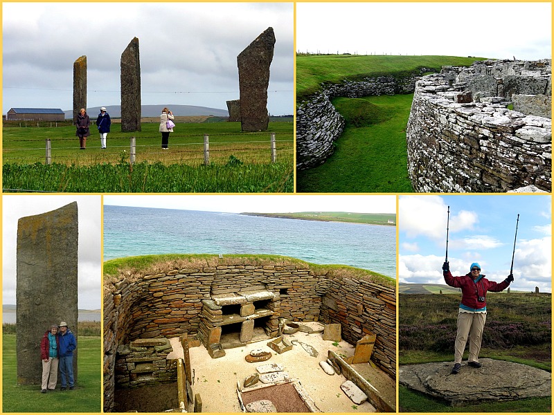
The Standing Stones o' Stenness, photo above, upper left. The site's been carbon dated to around 3000 B.C. Now that's old requiring a recalibration of my sense of time. Given the ravages of time, and the occasional farmer removing other stones with dynamite, these three stones of the main circle have done well. Upper right, Skara Brae, the remains of a Mesolithic village buried until winds and tides uncovered it in the mid 1800's. The complexity of the village structures, defensive walls, bed frames, storage cabinets and hearths, the fine stonework, combined require a reevaluation of the brutish stereotype of early peoples. In the photo lower right, another in the Rock Goddess photo series begun during our 2008 Scottish hiking vacation. Bottom center, living quarters interior at the Skara Brae site. In this photo a stone bed frame right center, grinding mill, hearth and mantle piece, center top to bottom and closet, lower left. Photo above, lower left, two travelers not quite as old as the stone behind them.
| | | Return to Home Page | | |
|---|
The Orkney's past, present and probable future are tied to the North Atlantic. The sea provides food, transportation and, today, revenue and jobs with offshore drilling companies and oil service industries.
Given often nasty sea states, winds and rain, no one goes to Orkney for the climate, the waters around the islands are dotted with boats from large commercial vessels to the small pleasure craft shown in the photo above, upper left. Upper right, years of erosion carved steep cliff all along the waters' edge. While the wind blew during our entire visit reaching 40 knots (46 mph) on the Atlantic side of the island neither of us blew away though we leaned a lot. A recent Atlantic hurricane (which locals telling us is entirely the fault of the United States) produced sustained winds of 70 knots (80 mph), not unusual. Lower left moi and mon petit chou at low tide on the causeway leading to the Brough Head Lighthouse on the Brough of Birsay off the north west coast of Mainland Orkney
| | | Return to Home Page | | |
|---|
In the photo above, upper left, The Italian Chapel built by Italian prisoners of war during WWII. Building materials were scarce though concrete and manpower, to build the Churchill Barriers on inlets to Scapa Flow, were in abundance. Two Nissen huts were provided by the camp commander. upper right, skilled Italians using paint on plaster board did the rest. The chapel interior is a tribute to the optical illusion as painted concrete turns to marble. Right center, Reminders of WWII, like this derelict Quonset hut, haunt the Island. Lower right, inhabitants of Orkney, courtesy of their Viking ancestors, are extraordinarily tall. At 8 feet, 2 inches, Kinlay makes even me appear vertically challanged. I look like a shrimp! Lower left, By mid August Heather, the national flower of Scotland, was in full bloom covering the land with a layer of pink and red.
| | | Return to Home Page | | |
|---|